IDrive Arkansas
- 520
- 4.2
- Installs
- 100.00K
- Price
- Free

Screenshots
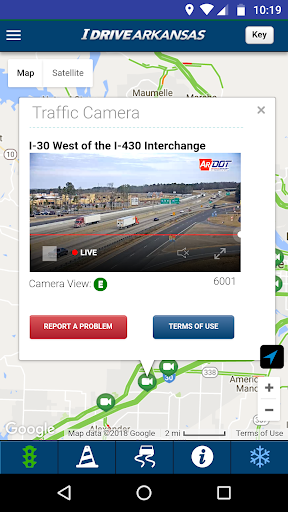
Analysis by Reviewed APKs
IDrive Arkansas is a road-information app for people driving on Arkansas highways. It brings together construction zones, traffic cameras, closures, weather details, and practical stops such as rest areas on a state map. I found its appeal straightforward: it helps answer what the road ahead looks like before a trip or a commute. It is a focused companion for Arkansas travel, not a general-purpose navigation app.
Before the Highway Drive
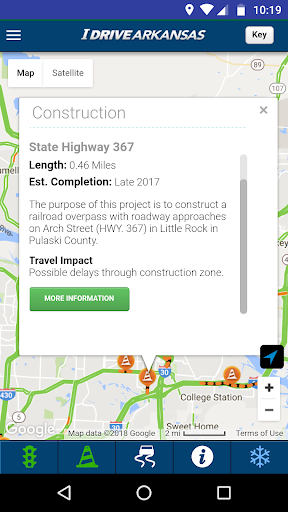
Picture a weekday morning when I need to cross town using a state highway, or a weekend trip that takes me through unfamiliar parts of Arkansas. Before pulling out, I can open IDrive Arkansas and check where construction zones are located. If traffic cameras are available for the stretch I care about, their live views give me a more tangible sense of conditions than a road marker alone.
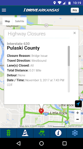
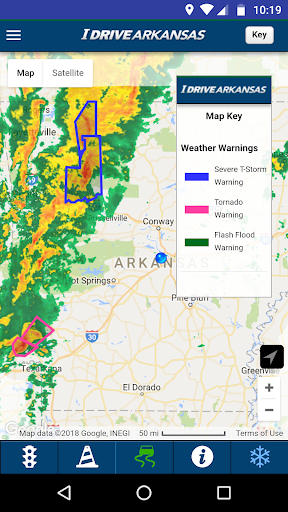
I can also bring weather radar into that quick check, which is useful when the forecast looks unsettled and I want to see whether storms overlap my route. Closures, flooded highways, and alternate routes are part of the same road-information mix. Rather than treating one map symbol as the whole story, I can look at the road, traffic, and weather together before deciding how to approach the drive.
A Road Tool, Not Navigation
The obvious comparison is a standard map or navigation app, but IDrive Arkansas has a narrower job. Its focus is Arkansas highway information: construction, live traffic and cameras, closures, weather, winter road conditions, and highway facilities. That focus can make it useful alongside a route planner when I want state-road context, rather than replacing the app I use to navigate turn by turn.
It is not presented as a broad travel guide or a general navigation service. The material describes road conditions and state highway resources, not business discovery, transit planning, or voice-guided directions. I would open it to check a highway situation, not expect it to plan every part of a vacation. Knowing that boundary makes the app easier to judge: it is a specialist reference for Arkansas roads.
Make Checks a Habit
A useful routine is to check the app before leaving, especially when the route includes a known work zone or the weather is changing. I can scan construction locations first, then look at traffic cameras and radar for the sections that matter. That keeps the check focused instead of turning a simple commute into a long session of exploring every map layer.
For a longer drive, I would revisit the information before setting off for the next leg rather than assuming the first glance remains current. The description says highway data is delivered in real time from crews in the field, so the app is intended for changing road conditions. I can also keep practical destinations in mind, such as welcome centers, rest areas, or park-and-ride lots, when planning a route.
More From Our News Desk

Zoom Meetings, Google Meet, or Teams: Which Is Easiest to Join?

How I Build a Free Streaming Lineup With Tubi

Why Crunchyroll Is the Default Anime App for So Many Fans

YouTube TV: A Practical Guide to Cutting Cable

Rummikub and the Small Comfort of Phone Games
TeamViewer Remote Control or AnyDesk for Helping Family?
Who May Find It Useful
I would recommend IDrive Arkansas to Arkansas residents who regularly use state highways, commuters who want a quick look at construction and traffic, and visitors driving across the state. The combination of camera views, closures, weather, and road facilities makes it relevant to both a familiar weekly route and an occasional longer trip. It is especially sensible for people who prefer checking road context before they get behind the wheel.
It may not suit someone looking for a complete navigation replacement or a road-information app for travel outside Arkansas. Drivers who rarely use state highways may have little reason to open it often. I also would not treat a road map as a reason to check a phone while driving; the practical value is in looking before departure or when safely stopped. For those limits, its focused role is easy to understand.
IDrive Arkansas is developed by NIC Inc. On Google Play, it has over 100,000 installs and a 4.2-star rating from 520 ratings. The app is free to download, has no in-app purchases, and contains no ads. Its content rating is Everyone, making the store's age classification suitable for a general audience.
The current version is 410.0. IDrive Arkansas was released on January 9, 2014, and was last updated on August 5, 2025. The available app information does not provide a minimum Android version, so anyone checking device compatibility should consult the Google Play store page for the requirements shown for their device.
A Closer Look at Arkansas Road Information
Opening the Road Map
When I first opened IDrive Arkansas, the clearest idea was its scope: this is about the state's highways, not every possible part of getting around. That focus gives the app a practical purpose from the start. Instead of promising a broad travel experience, it groups the kinds of road details that can matter before a drive, from construction to closures and weather.
The initial setup details are not spelled out in the app information, so I won't pretend to have gone through a particular onboarding sequence. What I can say is that the described experience centers on viewing highway information and activating features such as live traffic, cameras, and radar. For a quick pre-trip check, that is a useful, understandable starting point.
Checking Conditions Day to Day
In everyday use, the key question is whether a particular stretch of highway has something that could change my plans. IDrive Arkansas brings active construction zones and closed or flooded highways into view, while live traffic and cameras can help me assess movement around those areas. I like the practical sequence: locate the issue, check the available visual context, then consider whether an alternate route is relevant.
The app describes its highway data as real-time information supplied by crews in the field. That makes it appropriate for checking changing conditions, rather than relying only on a memory of what the road was like last week. I would still use it as a reference when planning, not as a substitute for attention to the road or for making careful decisions while driving.
Useful Details Beyond Traffic
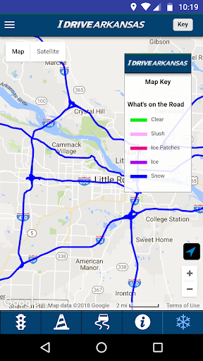
The standout feature is how many highway-specific layers sit alongside traffic. Weather radar and warnings can add context when storms are nearby, while winter road conditions address a different kind of trip concern. The app also includes alternate routes, weight-restricted highways and bridges, and markers for Arkansas welcome centers and highway rest areas.
That range makes IDrive Arkansas more than a simple construction map without turning it into a general-purpose travel directory. Commuter park-and-ride lots are included too, which may be useful for someone arranging a regular commute. I would not assume every feature matters on every drive; the value is having relevant state-road information available when a particular route or season calls for it.
A Practical Pre-Trip Routine
For a routine commute, I would make a short check before leaving: look for active construction on the highway portions of the trip, then check live traffic or cameras where available. If the weather is unsettled, I would add radar and warnings to the scan. That is enough to catch a potential complication without turning a familiar morning into a full route-planning project.
On a longer drive, I would also note useful stops and revisit closures or weather between legs while safely parked. If I have a concern about the state highway system, the app offers ways to report problems or littering and to submit questions to the Arkansas Department of Transportation. It also lets users request a complimentary Arkansas highway map and learn about voter-approved construction programs.
Keep Its Scope in Mind
The main limitation is also the app's defining choice: its information is centered on Arkansas highways. That is a good fit for local drivers and visitors crossing the state, but it is not a universal road companion. Anyone who expects comprehensive navigation or information for a wider region should keep using other tools for those needs.
The app's many categories may also be more useful on some trips than others. A short drive with no highway travel may not call for checking bridge restrictions, winter conditions, or welcome centers. I would treat IDrive Arkansas as a source to consult when its specific information is relevant, rather than an app that needs to stay open throughout every journey.
IDrive Arkansas earns its place as a focused road-information companion. Construction locations, traffic cameras, closures, weather, winter conditions, and useful highway facilities cover a practical set of questions for driving around the state. Its value is clearest when I check before a trip and pair it with a separate navigation tool where needed.
I recommend it to Arkansas drivers and visitors who want highway-specific context before setting out. If you need a broad navigation app or travel information beyond Arkansas roads, it will not fill that role by itself. For the right audience, though, its focused collection of road details makes it a sensible free download.
IDrive Arkansas Frequently Asked Questions
What is IDrive Arkansas used for?
IDrive Arkansas provides information about Arkansas highways, including construction zones, live traffic and cameras, closed or flooded roads, alternate routes, weather radar and warnings, and winter road conditions. It also shows highway rest areas, welcome centers, park-and-ride lots, and weight-restricted roads and bridges. The app includes ways to report highway problems or littering and contact the Arkansas Department of Transportation.
Which devices can run IDrive Arkansas?
IDrive Arkansas is an Android app available through Google Play. The available app information does not specify a minimum Android version, and device compatibility can vary. Check the Google Play store page for the current requirements shown for your device before installing.
Is IDrive Arkansas free?
Yes. IDrive Arkansas is free to download on Google Play. It has no in-app purchases and contains no ads, according to the available app details. Store information can change over time, so the Google Play page is the place to check for current terms.
Does IDrive Arkansas replace a navigation app?
IDrive Arkansas focuses on Arkansas highway conditions and resources, such as construction, traffic cameras, closures, and weather. It is not described as a general-purpose navigation app, so someone who needs route guidance should use a navigation tool for that job and consult IDrive Arkansas for its state-highway information.
Who should use IDrive Arkansas?
It is most relevant to Arkansas residents, commuters, and visitors who drive on the state's highways and want to check conditions before a trip. It may be less useful to people who rarely travel on Arkansas roads or who need a broad travel app covering other regions. Its content rating is Everyone.
Pros
- Combines construction, closures, traffic cameras, and weather information for Arkansas highways.
- Includes useful road facilities such as rest areas, welcome centers, and park-and-ride lots.
- Free to download, with no ads or in-app purchases.
- Offers ways to report highway problems and contact the Arkansas Department of Transportation.
Cons
- Its focus is Arkansas highways, so it is not a broad regional road-information app.
- It is not presented as a replacement for a general navigation app.
- Some of its highway-specific categories may be unnecessary for routine short trips.
- Category
- Travel & Local
- Version
- 410.0