HuntStand: GPS Maps & Tools
- 22.18K
- 2.4
- Installs
- 1.00M
- Price
- Free

Screenshots
Analysis by Reviewed APKs
HuntStand: GPS Maps & Tools is a hunting map and planning app for people who want to scout locations, mark important spots, and navigate while outdoors. I found its appeal in the way it brings mapping, land information, and hunting-focused tools together. It suits hunters who like to plan ahead on a phone, though the paid tiers and busy feature set may not fit everyone.
Planning a Day in the Field
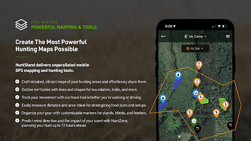
When I first opened HuntStand, I thought about the small decisions that go into a hunting day: where to park, which way to walk, and where to mark a stand or other useful location. The GPS map can show my current position, trace my path as I move, and let me add markers. That makes the app useful before leaving home as well as when I am already outside.
For a scouting session, I could plan a hunt area, check satellite imagery, and save important locations on the map. HuntZone adds another planning layer by estimating how scent may travel, with hourly predictions available up to 72 hours ahead. I like that these tools relate to practical choices rather than turning the app into a general outdoor feed. The value depends on using them as aids, not as a substitute for field judgment.
Maps, Not a Hunting Community
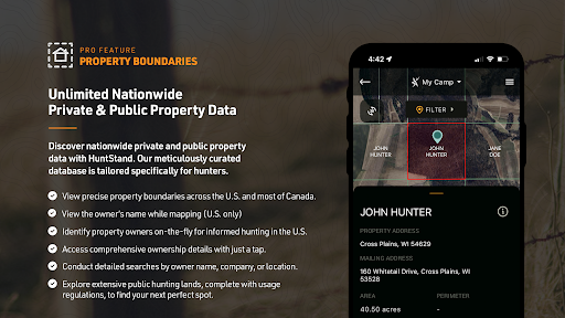
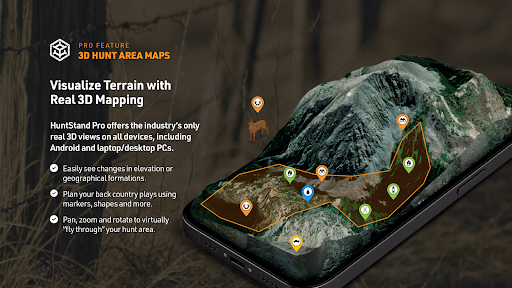
Compared with a basic map app, HuntStand is built around hunting areas and land research. Its free mapping tools include GPS position, route tracing, map markers, area customization, satellite imagery, scent forecasting, and a digital rangefinder. Paid Pro options add features such as property boundaries, ownership information, public hunting land maps, aerial imagery, 3D maps, and offline maps.
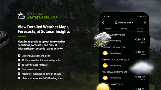
That focus also defines what HuntStand is not: it is not simply a road-navigation app, and it is not a broad social network or a general weather app. Its tools are most relevant when I am planning or navigating a hunting area. Some of the most detailed land and deer information is tied to paid tiers, so someone who only needs occasional directions may find a simpler map app more appropriate.
Make Mapping a Habit
I get more from a mapping app when I add details as I scout rather than trying to remember them later. HuntStand lets me place markers for useful locations and customize a hunting area, so a quick note on the map can make a later visit easier to plan. Tracing a route while moving also gives me a record of where I went, rather than relying on memory after a long day outdoors.
Sharing hunt areas with buddies, lease partners, or family can make planning more coordinated. I would keep the map focused: mark the locations I genuinely need, review the area before setting out, and check any forecasts or imagery that matter to that particular trip. For repeated use, it is worth learning which tools are included free and which require a subscription, so the app does not become a collection of features I rarely touch.
More From Our News Desk

Zoom Meetings, Google Meet, or Teams: Which Is Easiest to Join?

How I Build a Free Streaming Lineup With Tubi

Why Crunchyroll Is the Default Anime App for So Many Fans

YouTube TV: A Practical Guide to Cutting Cable
Rummikub and the Small Comfort of Phone Games
TeamViewer Remote Control or AnyDesk for Helping Family?
Who May Find It Useful
I would recommend HuntStand to hunters who regularly scout or revisit specific areas and want mapping, location markers, and hunting-oriented planning tools in one place. It is especially appealing if property information, public-land maps, satellite imagery, or deer-focused tools are part of your routine. The free features provide a way to start mapping, while the paid plans expand the available maps and specialized tools.
It may be less suitable for someone who only needs simple navigation, wants every feature without a subscription, or dislikes ads and in-app purchases. The amount of information can also feel like more than a casual user needs. On Google Play, its rating is 2.4 from around 22,000 ratings, so I would try the free experience and judge its fit for my own area before paying.
HuntStand: GPS Maps & Tools is made by GSM Outdoors and is available on Google Play for Android. It has over 1 million installs and a 2.4-star rating from 22,185 ratings. The app is free to download and contains ads, with in-app purchases. Google Play gives the content rating as Everyone.
The current version is 8.1.13. The app was released on November 21, 2013, and its most recent update date is October 12, 2026. In-app product prices range from $5.99 to $99.99 per item. The minimum Android version is worth checking on Google Play, since requirements can vary.
A Closer Look at HuntStand
A Map-First First Impression
When I first opened HuntStand, I saw a tool aimed at planning and navigating hunting areas, not a generic collection of outdoor articles. The app’s redesigned look is intended to support scouting and navigation, while the core idea stays practical: look at a map, shape an area, and save locations that may matter later. That map-first approach makes sense for hunters who prefer to prepare before heading out.
I would begin by exploring the free GPS mapping tools and seeing how they match the places I actually visit. The app can show my current position, trace my movement, and save markers such as tree stands. Since available land details and imagery differ by plan, I would also check which information is accessible for my area before building a routine around a particular layer.
Using It on a Hunt
The day-to-day experience centers on maps and location awareness. I can look at a hunting area, follow my position as I move, and add markers for places I want to remember. The digital rangefinder is another field-oriented tool, letting me calculate distances. These functions are easy to understand as a group: they help turn a map into something I can use while scouting or moving around outdoors.
HuntZone gives the planning side a more specific purpose by showing scent-impact predictions hour by hour, for up to 72 hours. I would check it before a trip and use it as one consideration when choosing where to go. The app’s usefulness depends on how often I hunt and how much detail I want to keep on hand; a casual outing may not call for every available layer or forecast.
Tools Beyond Basic Mapping
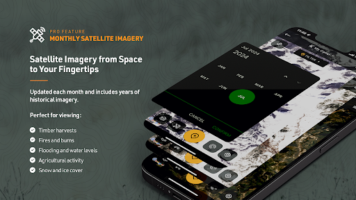
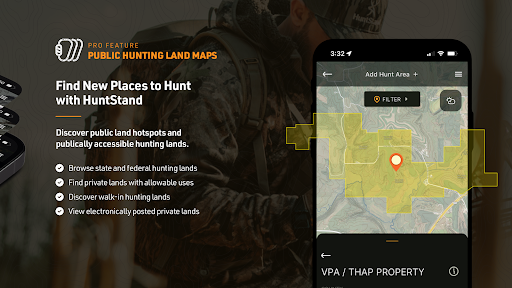
The feature set becomes more specialized with paid plans. HuntStand Pro includes nationwide property lines, ownership data, public hunting land maps, monthly satellite imagery with a historical archive, high-resolution U.S. aerial imagery, 3D mapping, and unlimited offline maps. Those options are aimed at people who want to research access and terrain in more depth, rather than simply save a few points on a map.
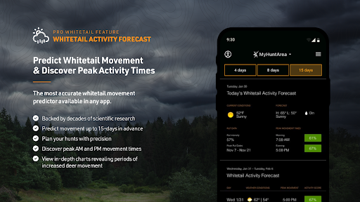
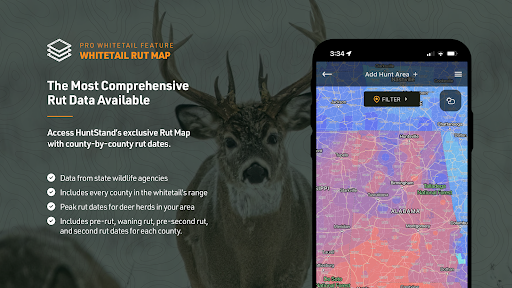
Whitetail-focused tools add another layer for deer hunters. The Pro Whitetail tier includes a 15-day activity forecast, a county-level rut map for the U.S., and a whitetail habitat map for the U.S., alongside Pro features. I like that the app distinguishes general mapping from these specialized tools. The trade-off is that users need to compare tiers before deciding whether those extras justify the cost.
A Simple Scouting Routine
A practical routine could start at home with a review of the hunting area and available satellite imagery. I would customize the map, mark a few locations worth checking, and share the area with hunting partners if we are coordinating. Before leaving, I could review the scent forecast and save maps for offline use if my plan includes the Pro feature.
Once outside, I could follow my position, trace the route, and add markers as new places become relevant. After the outing, those saved details can make the next scouting visit easier to prepare. The point is not to record every step, but to keep a useful map of the things I would otherwise need to remember. That measured approach helps the app stay practical instead of overwhelming.
Limits to Keep in Mind
HuntStand’s strongest tools are not all part of the free experience. Property boundaries, ownership details, public-land maps, offline maps, and several whitetail features are associated with paid plans. The Google Play information gives a broad in-app purchase range, while the app description also outlines subscription tiers. I would check the current plan details in the store before committing, especially if one specific feature is the reason for downloading.
The Google Play rating is 2.4 stars from 22,185 ratings, a mixed signal worth weighing alongside the feature list. Ads are present, too. And while a map can make planning easier, a forecast or mapped boundary should not be treated as a replacement for paying attention to conditions and the place itself. The app is most convincing for people who will return to it regularly and use its specialized mapping tools.
HuntStand brings hunting maps, GPS marking, route tracing, scent forecasts, and specialized land and deer tools into one app. I like its practical focus and the fact that basic mapping is available to start with. Its deeper value, though, depends on whether the paid features match the kind of scouting and hunting I actually do.
I would try HuntStand if I regularly plan trips around specific hunting areas and want those details organized on my phone. Casual users may be happier with a simpler map, while frequent hunters should compare the subscription tiers and test the free tools first. It is capable, but its low store rating and paid feature split make a careful trial sensible.
HuntStand Frequently Asked Questions
What is HuntStand: GPS Maps & Tools used for?
HuntStand is used to map and plan hunting areas. Its tools include GPS positioning, route tracing, map markers, customized hunt areas, satellite imagery, scent-impact forecasts, and a digital rangefinder. Paid tiers add land and property information, public hunting land maps, offline maps, and deer-focused features. The mix is aimed at scouting and navigation rather than general-purpose travel.
Which devices can run HuntStand: GPS Maps & Tools?
HuntStand: GPS Maps & Tools is an Android app available through Google Play. It offers mapping and navigation features for use on a phone, including position tracking and saved map markers. The minimum Android version can vary with app updates, so check the current Google Play store information to make sure your device meets the requirement.
Is HuntStand: GPS Maps & Tools free?
The app is free to download and includes ads, but it also offers in-app purchases. Google Play shows in-app product prices ranging from $5.99 to $99.99 per item. The app description separates free mapping tools from features available with Pro and Pro Whitetail plans. Check Google Play for current subscription details and pricing before purchasing.
Does HuntStand: GPS Maps & Tools need an internet connection?
HuntStand Pro includes unlimited offline maps, so some maps can be saved for use without an internet connection with that paid plan. The app also has features that use imagery and forecasts. Which tools are available offline may depend on the feature and plan, so check the current app details in Google Play if offline access is important to your trips.
Who is HuntStand: GPS Maps & Tools best for?
It is best suited to hunters who scout or return to specific areas and want mapping, GPS markers, and hunting-focused planning tools. People interested in land details, offline maps, or whitetail forecasts may find the paid tiers more relevant. If you only need ordinary directions or prefer not to use ads or in-app purchases, a simpler mapping app may suit you better.
Pros
- Free GPS mapping includes current position, route tracing, and saved location markers.
- HuntZone forecasts scent impact by the hour for up to 72 hours.
- Paid tiers offer property, public-land, offline, and whitetail-focused map tools.
- Hunt areas can be customized and shared with hunting partners.
Cons
- Many detailed property, offline, and deer tools require a paid plan.
- The app contains ads and offers in-app purchases.
- Its Google Play rating is low at 2.4 stars from 22,185 ratings.
- Category
- Sports
- Version
- 8.1.13